
Parkland Neighbor Record Sources
Different records answer different block questions. The map defines which lots are near a Parkland address. The tax roll names each owner of record. The precinct tool confirms election geography, not a list of voters. An HOA inventory supplies organizational contacts, not resident names. Keeping those roles separate prevents a likely owner from being mislabeled as a current neighbor.
| Official source | Block-level evidence | How to reach it |
|---|---|---|
| BCPA parcel map | Lot shapes, adjacent parcels, owner name, situs, use | Free map, address or folio |
| BCPA property roll | Owner, mailing address, legal description, exemption clues | Free property search |
| Broward precinct finder | Precinct, polling place, and district for one address | Individual address search |
| Parkland HOA inventory | Association and manager contacts by community | City-published contact list |
| City public records | Permits, code matters, liens, maps, meeting records | Online, phone, email, or inspection |
Start with the narrowest record that fits the question. For an adjoining lot, use GIS. For a community concern, contact the listed association or City Clerk. When a public portal cannot answer, Florida Public Records Law allows a focused request for an existing city record, subject to exemptions.
Click Around a Parkland Block
The BCPA parcel map supports Parcel ID, Name, and Address tabs. In the address tab, enter the house number and street name while omitting the direction and street type. Select the best candidate, then examine the polygons that touch it. Geometry catches rear-lot neighbors and corner parcels that a list of house numbers can miss.
- Find the known address and confirm its folio, municipality, and legal description.
- Click the parcel on each side, across the road, and behind the starting lot.
- Use Collect Parcels to keep several lots together, then review the result grid.
- Open each parcel card and compare situs, mailing address, owner, and homestead clues.
- Record only what the roll proves, then contact a person directly when confirmation is appropriate.
The map also offers Unselect Parcel, print, measurement, and location controls. Measurement does not create a resident-radius search. For a full named road rather than the immediate block, use the Parkland street directory workflow.
Read Parkland Parcel Results
A parcel result reports land, not a household. GIS can show the parcel number, owner name, situs address, millage, use code, square feet, values, effective age, and neighborhood. The linked property detail adds a legal description, exemptions, taxable value, sales references, and mailing address.
| Map field | What it can establish | What it cannot establish |
|---|---|---|
| Situs address | Physical location of the parcel | Every current occupant |
| Owner name | Current name on the tax roll | That the owner lives there |
| Mailing address | Destination for tax mail | A second residence |
| Homestead flag | Primary-residence tax claim | A household roster |
| Legal description | Stable lot and subdivision identity | A person's identity by itself |
This distinction matters in Parkland, where a trust or entity may hold title and the mailing destination may be elsewhere. Compare the map, parcel card, and deed before deciding what an ownership entry means.
Find Parkland's Rear-Lot Neighbors
Street order is not block geometry. A rear boundary may touch a home on another road, and a corner lot may face away from the address being studied. Cul-de-sacs, ponds, preserves, gates, and irregular planned-community plats make a simple sequence of house numbers incomplete.
Turn on parcel, street, subdivision, city-limit, and ZIP layers one at a time. Collect only the polygons that actually meet or closely surround the starting lot. A narrow map view avoids pulling in an entire Parkland street. This is the page's block angle: identify the immediate ring and stop when the question expands beyond it.
Note: A map polygon proves physical adjacency; it does not show whether the people associated with two lots know each other.
Parkland Boundaries Change the Block
A postal Parkland address, an incorporated-city parcel, and a property in a Parkland-area ZIP are not the same thing. Both 33067 and 33076 include Northwest County parcels. Confirm the municipality field and city-limit layer instead of relying on the mailing city.
This affects the custodian. Parkland City Hall holds city permits, code matters, liens, maps, and meeting records for the incorporated city. County records cover deeds and the property roll. A parcel outside the boundary may use a Parkland mailing label while its local records sit with another jurisdiction. The Broward GeoHub adds jurisdictional and county map context when the BCPA view is not enough.
Parkland Associations Add Context
Parkland's official HOA inventory maps named communities and subcommunities, including the many sections of Heron Bay. It identifies associations and management contacts. It is not a membership roll, and it does not prove who lives in a unit. Use it to ask a community question, locate the correct manager, or understand why two nearby lots belong to different organizations.
Parkland City Clerk
Custodian Alyson Morales handles city-created public records at City Hall, 6600 University Drive. Phone requests may be made at 954-757-4132.
HOA contact inventory
The city list gives public organizational contacts for named communities. Associations may ask that a contact be removed or replaced.
Broward Property Appraiser
BCPA supplies parcel identity and ownership. Use it before asking an association about a specific lot.
The removal and substitution notice is a useful privacy clue. Public organizational contact information can change even while the association continues to exist. No authoritative public congregation, alumni, block-watch, or HOA member roster was found, so do not imply one exists.
Voter Tools Do Not List Neighbors
Florida's voter status form is an individual verification tool. It requires first name, last name, and date of birth. Broward's Precinct Finder is keyed to an address and returns precinct, polling, and district information, but no names of Parkland neighbors.
Voter-registration records are public subject to Florida Statutes sections 97.0585 and 119.071, yet Social Security numbers, driver-license or state-ID numbers, signatures, and protected addresses are exempt. Preregistered 16- and 17-year-olds receive broader confidentiality. A request for a lawful public extract is different from the self-service portal and must respect those limits.
Choose Official Parkland Block Records
Commercial neighbor tools often merge old addresses, phones, relatives, and marketing data without showing when a field changed. Official sources are narrower. They show which custodian published the record, what the field means, and where a corrected or certified version can be sought.
| Choice | Strength | Main limit |
|---|---|---|
| BCPA and GIS | Current parcel geometry and owner roll | Owners are not a full household |
| City or county request | Record from the responsible custodian | Exemptions and service charges may apply |
| Commercial category | May combine many broad sources | Age, origin, and correction path may be unclear |
Use the official parcel as the anchor and treat any broad commercial claim as an unverified lead. If a Parkland record appears wrong, contact the office that maintains it rather than repeating it to others.
Keep Safety Searches Separate
A parcel lookup should not be turned into an accusation. When the question is about an official safety record, use the agency designed for that record and match identity details with care. The Florida offender and predator search provides name and geographic modes, while the Florida Department of Corrections separately covers state custody and supervision.
The official registry screen captured for Parkland neighbors is shown below.
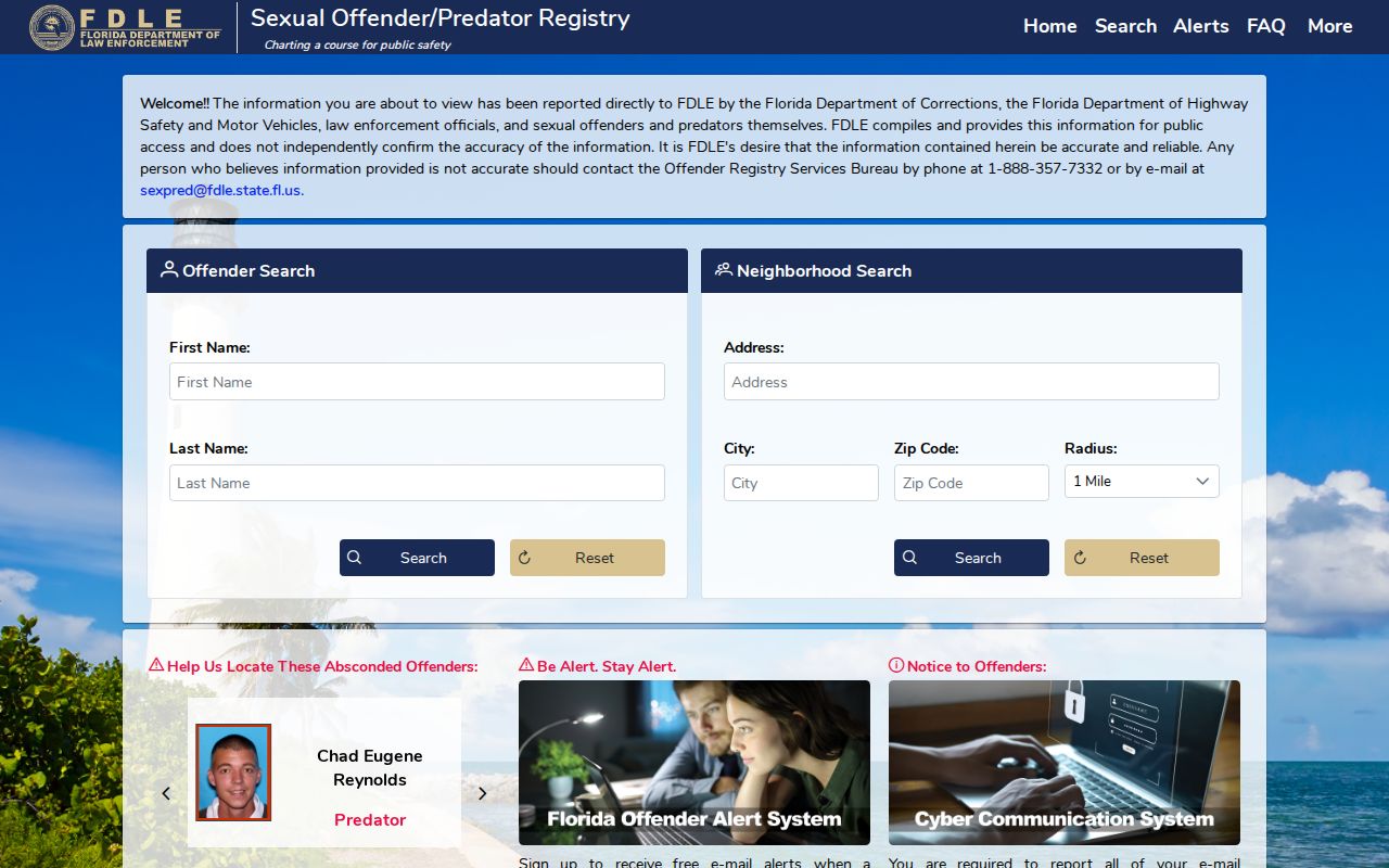
Read the agency's warnings and verify that a result matches the intended person. Do not post a same-name result or use a public map to confront someone.
Respect Parkland Neighbor Privacy
Public parcel data cannot reveal renters, children, relatives, guests, or every adult in a home. Utility customer files and motor-vehicle personal information are not an open block directory. Florida's Address Confidentiality Program supplies substitute addresses to qualifying survivors, and section 119.071 shields protected addresses and identity fields.
A neighbor lookup should support a normal introduction, civic question, reunion, or personal safety check. It should never become repeated monitoring. Florida stalking law, section 784.048, covers willful, malicious harassment and cyberstalking that causes substantial emotional distress without legitimate purpose.
City records also have a defined fallback when a block question concerns public work rather than private life. Parkland City Clerk Alyson Morales is the municipal custodian. Requests may be made by phone, through the city's email contact, or in person at City Hall. Florida law ordinarily does not require a purpose statement or special form. Name the department, date range, street address or folio, and record type. Ask to inspect the material if no copy is needed. The city publishes charges of 15 cents for a one-sided page, 20 cents for a two-sided page, and up to $1 for certification, with a reasonable service charge possible for extensive staff or technology use.
Route the subject correctly. City Hall handles Parkland permits, code matters, liens, maps, meetings, and other city-created files. Police records go to the Broward Sheriff's Office, while fire-rescue records go to Coral Springs-Parkland Fire. Recorded deeds remain with Broward Records, Taxes and Treasury, and court or probate records remain with the Broward Clerk. This split keeps a block inquiry focused and avoids asking one office to assemble a private resident profile it does not maintain.
When an association contact is the better route, ask about the community issue without seeking a member list. The Parkland inventory can identify the association or manager for a named community, but its contacts are voluntary and may be removed or replaced. That is enough for a question about a common area, meeting, or neighborhood program. It is not authority to identify every person behind a gate or within a subdivision.
Lawful use. Use Parkland neighbor records with care. Never track, threaten, intimidate, or publish sensitive facts about another person.